
LiDAR mapping looks fast and precise. A drone flies over a site, collects data, and builds a detailed map. For many property owners, that sounds simple enough.
But here’s the problem. The data can look perfect on screen and still be wrong.
That mistake shows up later. A grading plan doesn’t match the site. Water flows the wrong way. Contractors stop work because something feels off. Now the project slows down, and costs start to rise.
This happens more often than people think. And it usually comes down to one missing piece: ground control.
A recent case shared by surveyors showed how easy it is for LiDAR mapping to go wrong.
A drone scanned a site in several flights. Each flight used a different setup for positioning. No one placed proper ground control points on the site.
At first glance, the data looked clean. The surface looked smooth. Elevations seemed consistent.
Later, the team noticed something strange. Parts of the site didn’t line up. Some areas sat slightly higher than others, even though they should match.
That small shift caused bigger problems. The design team could not trust the elevations. They had to pause and review everything.
The issue was not the drone. It was not the LiDAR sensor.
The issue was control.
Many people believe LiDAR mapping works like taking photos from the air. Fly once, process the data, and you’re done.
That idea sounds nice, but it skips the most important part.
LiDAR collects millions of points in space. Those points need a reference. Without it, the data floats. It may look detailed, but it does not sit correctly in the real world.
Accurate LiDAR mapping depends on how the data connects to known positions on the ground. That connection does not happen on its own.
Someone has to build it.
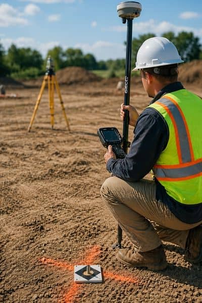
Ground control points are fixed spots on the site with known coordinates. Surveyors measure them using precise equipment before the drone ever takes off.
These points act like anchors. They hold the LiDAR data in place.
When the drone collects data, the system uses those points to align everything correctly. Each flight matches the same reference. The elevations stay consistent across the entire site.
Without those anchors, the data can shift. One flight may sit slightly higher. Another may tilt or drift. The difference may seem small, but it adds up fast.
That is how clean data turns into bad information.
This is where problems start to show up for clients.
First, elevations become unreliable. A surface may appear flat when it is not. Even a few inches can change how water moves across a site.
Next, different parts of the map stop matching. Edges don’t line up. Features shift out of place.
Then design work suffers. Engineers rely on elevation data to plan grading and drainage. If the base data is off, the design will be off too.
Construction teams feel it soon after. They stake the site based on the plans, but field conditions don’t match. Work slows down while teams figure out what went wrong.
In many cases, the project needs new data. That means more time, more cost, and more frustration.
San Jose projects leave little room for error.
Sites are tight. Grades need to meet strict standards. Drainage must work the first time, especially in developed areas.
Small elevation mistakes can cause permit issues. They can also affect how water moves near buildings and streets.
Infill projects face even more pressure. There is no extra space to adjust later. The data has to be right from the start.
That is why accurate LiDAR mapping matters so much here. It is not just about having data. It is about trusting it.
A professional workflow solves these problems early.
Surveyors set ground control points across the site before flying. They use consistent positioning during every flight. They also check the data after processing to confirm accuracy.
Checkpoints play a key role. These are extra points used to test the final data. If the LiDAR results match those known points, the team knows the data is reliable.
Processing also matters. Raw data needs alignment and cleaning. Small errors get corrected before delivery.
This process takes more effort, but it prevents bigger issues later.
Before ordering LiDAR mapping, ask a few simple questions.
Will the team use ground control points on-site?
How do they confirm elevation accuracy?
Do they include checkpoints in their work?
How do they handle multiple flights across one site?
Is the final data suitable for engineering and construction?
Clear answers to these questions show whether the data will hold up under real use.
LiDAR mapping can deliver strong results. It captures detail quickly and helps teams move faster.
But speed does not guarantee accuracy.
The real strength of LiDAR mapping comes from how the data gets controlled, checked, and aligned. Ground control points make that possible.
Without them, the data may look good but fail when it matters most.
With them, the data supports every decision that follows.
That different shapes how a project moves forward.


