Wildfires leave more than burned homes behind. They also change the land itself. Across Los Angeles, many property owners now face the challenge of rebuilding after fire damage. However, before new construction begins, professionals often recommend a topographic survey. This survey gives architects, engineers, and builders a clear picture of the land after the fire. In many cases, the ground no longer looks the same as it did before. Soil may move, slopes may weaken, and water may flow in new ways. As this guide explains, accurate land data becomes important before rebuilding can safely move forward.
Many homeowners expect rebuilding to start right after cleanup. Yet wildfires often change the land in ways that people do not notice right away.
For example, fire burns plants and grass that once held the soil in place. As a result, the ground can become loose. In hillside areas of Los Angeles, this can raise the risk of erosion.
In addition, burned tree roots stop holding the soil together. Over time, the ground may sink or move. Because of this, the land may no longer match the measurements taken years ago.
Heavy cleanup equipment can also affect the land. Bulldozers and trucks move debris during the recovery process. As they work, the surface of the property may change height in some areas. Even small changes in elevation can affect future construction.
In situations like this, surveyors often perform an updated topographic survey to capture the land’s current shape. This process maps the property exactly as it looks today, not as it looked before the wildfire.
Some homeowners think they can use old property plans when rebuilding. However, that idea can lead to problems later.
Older surveys show how the land looked in the past. Yet fire damage can change slopes, water flow, and ground levels. Because of this, plans based on old data may not work anymore.
For example, an architect may design a new foundation using an old site plan. Later, builders may find that the ground slopes differently than expected. When that happens, engineers must change the design. That process takes extra time and money.
A topographic survey helps avoid this issue. It gives fresh measurements of the land. As a result, architects and engineers can design buildings that match the land today.
Rebuilding a fire-damaged home takes careful planning. Engineers must understand the land before placing a new structure on it.
A topographic survey helps engineers study several important things.
First, it shows the exact slope of the property. In hillside areas, slope angles affect how a foundation should be built.
Next, the survey shows elevation changes across the land. This helps engineers decide where structures should go.
The survey also marks features such as driveways, walls, trees, and utility areas. Even if some features burned or fell, surveyors can record their locations.
Finally, the data helps engineers plan drainage. After wildfires, rainwater may flow in new directions. Good drainage helps prevent flooding, erosion, and damage to foundations.
Because of these reasons, many rebuilding projects start with a topographic survey.
Los Angeles has many hillside neighborhoods. Areas such as the Hollywood Hills and Topanga sit on steep land. Therefore, rebuilding in these areas needs careful planning.
Wildfires often affect hillside communities the most. Fire burns the plants that once helped hold slopes in place. Later, heavy rain may cause soil to move.
Because of this risk, engineers need clear land data before new construction begins. A topographic survey shows the exact shape of the land. Contour lines on the map reveal how steep the slopes are and how the ground changes across the property.
With this information, engineers can design safer rebuilding plans.
Many homeowners wonder when a survey should happen during rebuilding. The process usually follows a few steps.
First, property owners arrange fire damage checks. Insurance companies and recovery teams review the site.
Next comes debris removal. Crews clear burned structures and damaged materials.
After the land becomes open and safe to enter, surveyors perform the topographic survey. They measure elevations, slopes, and features across the site.
Once the survey is finished, engineers and architects use the data to design rebuilding plans. These plans then go through the city permit process.
Finally, construction crews begin rebuilding the structure.
Because the survey happens early, it helps avoid design problems later.
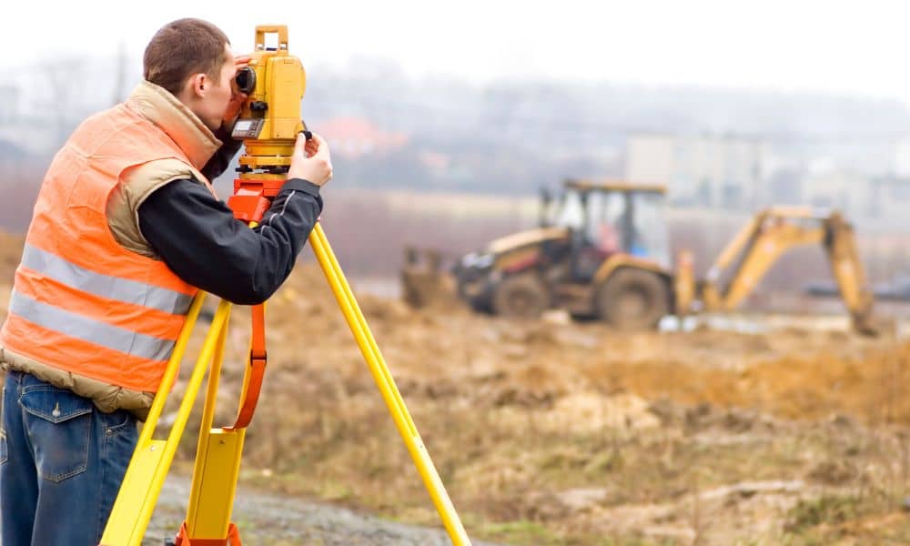
Surveyors use modern tools to measure land with high accuracy. These tools help them map properties safely and quickly.
For example, surveyors use GPS equipment to record exact positions across the site. They also use special instruments to measure angles and distances.
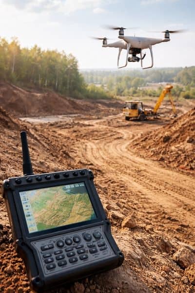
In larger areas, surveyors may use drones to collect aerial data. Drone mapping helps professionals see the land from above, especially on steep slopes.
Together, these tools create a detailed map of the property. The final survey usually shows contour lines, elevation points, and surface features. Engineers use this information to guide rebuilding plans.
Timing matters when planning a rebuilding project. Property owners should consider ordering a topographic survey soon after debris removal is complete.
At that time, the land is easier to see and measure. Surveyors can collect accurate data before design work begins.
Calling a surveyor early helps architects create plans faster. It can also help avoid delays during the permit process.
Most importantly, accurate land data helps prevent surprises during construction.
Rebuilding after a wildfire takes careful planning. The land may change in ways that are not easy to see. Soil may move, slopes may weaken, and drainage paths may shift.
A topographic survey provides the updated information needed to rebuild safely. It shows the true shape of the land so engineers and architects can design buildings that match the terrain.
For many property owners, this step becomes one of the first and most helpful parts of the rebuilding process. With accurate land data, rebuilding can move forward with greater confidence and fewer unexpected problems.


