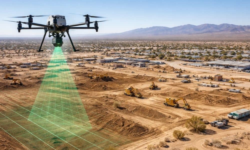
Victorville is growing fast. New homes, warehouses, solar projects, and road work continue to change the desert landscape. Because of this, clear land data is more important than ever. One of the best tools for collecting this data is drone-based LiDAR mapping. However, new FAA drone rules are now making this work harder.
Over the past few days, federal drone restrictions have changed how flights are planned. As a result, survey teams must adjust their schedules more often. For property owners, builders, and engineers, these changes can affect project timing and costs. Understanding how these new rules impact lidar mapping victorville projects can help teams avoid delays and stay on track.
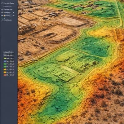
Many projects in Victorville rely on early land data. Engineers use LiDAR scans to design grading plans, study water flow, and build site models. Builders use this information to plan earthwork and manage crews. Property owners also depend on this data to make smart choices before building.
Before these rule changes, drone flights followed clear guidelines. Survey teams could plan work with confidence. Now, airspace limits can change quickly and with little notice. Because of this, flight planning has become more complex.
Victorville sits along major travel and shipping routes. As a result, it sees more of this airspace activity than many other desert towns. This makes lidar mapping victorville projects more likely to face delays.
In the past, drone pilots planned around fixed flight rules and clear temporary limits. Today, some airspace limits can appear fast when certain federal operations move through an area. These limits may not always show up clearly in flight planning tools.
This means flights may need to pause, shift, or reschedule. Even when skies look clear, airspace rules may still block legal flight. As a result, survey teams must stay alert and flexible.
For developers and property owners, this does not mean drone LiDAR is unsafe or illegal. Instead, it means projects now require better planning and more flexible schedules.
When LiDAR flights get delayed, the impact spreads quickly. Since engineers need LiDAR data to start design work, delays slow down site plans. This can also delay permits, contractor bids, and construction start dates.
In Victorville, many projects move on tight schedules. Even short delays can push back work by weeks. When that happens, costs often rise. Equipment rentals, labor scheduling, and material delivery can all become harder to manage.
In addition, desert land changes quickly. Wind, erosion, and early grading can change ground levels in a short time. When LiDAR flights get pushed back, data can become outdated. This increases the chance of design errors and repeat surveys.
Large projects feel the biggest impact. These often include:
These projects cover large areas and need wide flight paths. Because of that, they face more chances of running into restricted airspace.
Smaller sites may still face delays. However, large projects see bigger effects because more people, plans, and timelines depend on fast data delivery.
Because of these new rules, developers and engineers now ask different questions before starting LiDAR work. They want to know how schedules will stay flexible and what happens if flights get delayed.
Instead of focusing only on cost and speed, they now care about backup plans. They want to know how survey teams handle airspace changes and protect project timelines.
As a result, skilled LiDAR teams now spend more time planning ahead and communicating clearly. This helps clients stay calm and confident, even when schedules shift.
To keep projects moving, survey teams have changed how they work. They now check airspace rules more often and plan several flight windows instead of just one.
Some teams also mix drone work with ground surveys. This helps engineers receive partial data if full flights must wait. As a result, design work can still move forward.
Many teams also provide early surface models first. Later, they deliver final data with full detail. This keeps engineers working while full processing continues.
These changes help ensure lidar mapping projects stay reliable, even when flight conditions change.
Under the new rules, early planning makes a big difference. When developers involve survey teams early, they gain more scheduling options. This helps secure better flight windows and reduce delays.
Early planning also helps engineers organize design work more smoothly. With early data delivery, projects move forward without long waiting periods.
In fast-growing Victorville, this planning approach helps projects stay on time and within budget.
If you own land or plan to build, these changes should not stop you from using LiDAR. Instead, they show why working with skilled professionals matters more than ever.
By sharing project goals early and allowing flexible schedules, property owners can still receive accurate data on time. With smart planning, LiDAR remains one of the best tools for land analysis, design, and construction planning.
New FAA drone rules have created challenges, but they have also improved how survey teams plan their work. In Victorville, where development continues to grow, this careful planning helps projects move forward smoothly.
With flexible scheduling and skilled planning, lidar mapping remains a powerful tool for builders, engineers, and landowners. As rules continue to change, smart preparation will help protect timelines, budgets, and overall project success.


