
Walk onto almost any project site and you will see the same habit. Someone pulls out a phone, takes a few photos, and says, “We’re covered.” At first, that feels enough. However, when questions show up later, those photos often create more confusion than clarity. That problem is exactly why drone surveying is replacing traditional field photos on many modern projects. Surveyors, engineers, and property owners now want stronger visual proof, not just random snapshots. They want records they can measure, verify, and trust.
Field photos sound simple. Take a picture. Save it. Use it later. In reality, things rarely work that smoothly.
For example, a crew may photograph a stake, a corner marker, or a utility flag. Later, the office team reviews the image and asks basic questions:
Where exactly was this taken? Which direction was the camera facing? How far was this from the control point? Was anything just outside the frame?
Unfortunately, nobody knows for sure.
As a result, teams argue. Crews return to the site. Schedules slip. Clients get frustrated. Costs grow. All of that happens because the original documentation lacked structure.
Most field photos fail for the same few reasons. First, they are not tied to coordinates. Second, they show only one narrow angle. Third, they lack scale and context. Even worse, different crew members take photos in different ways.
So consistency disappears.
In many cases, photos also flip orientation or lose metadata when someone transfers files. Then the image no longer proves anything. It becomes just another picture in a folder.
From a client’s point of view, that creates risk. You may think the site’s condition looks clear. However, if a dispute starts, that photo may not hold up under review.
Therefore, many firms now treat random field photos as weak evidence instead of reliable documentation.
Poor documentation does not just annoy surveyors. It affects owners, builders, and developers directly.
For instance, imagine a grading dispute. A contractor claims the slope matched the plan. The owner disagrees. The only record is a blurry phone photo from two months ago. That image shows dirt — but proves nothing about elevation or limits.
Now the team must re-check, re-measure, and sometimes rework.
Similarly, boundary improvements often trigger neighbor complaints. A fence, wall, or driveway edge raises questions. Without strong visual records, the discussion turns into memory versus memory.
Because of that, projects face:
Good documentation prevents those headaches early.
Today, survey firms face more pressure than ever to prove site conditions clearly. Clients ask for backup. Engineers ask for verification. Attorneys ask for defensible records.
So firms changed their standards.
Instead of relying on scattered photos, many teams now build structured visual datasets. They want images tied to location, time, and measurable ground features. They want records the office can review without guessing.
That shift leads directly to drone surveying.
Not because drones look modern — but because drones produce organized visual evidence.
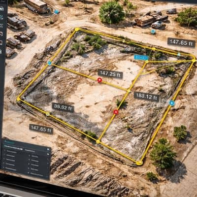
Drone surveying changes how teams capture site visuals. Instead of taking selective snapshots, crews capture full-site imagery in a planned flight.
As a result, nothing important sits just outside the frame.
Each drone flight links images to coordinates. That means every visual ties to real ground position. Office staff can open the map, click a point, and see the exact view from above.
In addition, drone surveying produces measurable imagery. Teams can check distances, areas, and relationships between features. Traditional photos cannot do that.
Drone flights also create timestamps and repeatable records. A team can fly the same site again and compare results. That helps track change over time.
So instead of guessing what the crew saw, everyone sees the same mapped reality.
Most clients think of drone surveying as a mapping tool. However, smart teams also use it as dispute protection.
For example, before construction starts, a drone flight captures existing site conditions. That record shows slopes, drainage paths, and visible improvements. If someone later claims damage or change, the team checks the baseline record.
Likewise, during construction, periodic drone flights document progress. Those records show where work stood on specific dates. That helps resolve timeline arguments quickly.
Drone surveying also supports:
Because of that, drone imagery often saves far more money than it costs.
Let’s make one thing clear. Drone surveying does not replace a licensed land surveyor.
A drone collects imagery and data. A licensed surveyor controls boundaries, coordinates, and legal decisions. Ground control points, field checks, and professional judgment still matter.
Think of drone surveying as a documentation layer. It strengthens the record. It does not replace expertise.
When firms combine ground control with drone imagery, they produce both legal reliability and visual clarity. That combination protects clients best.
Not every small job needs aerial documentation. Still, many projects benefit from it more than owners expect.
You should strongly consider drone surveying when:
In those cases, strong visual records reduce risk early.
People trust photos because they feel real. However, random field photos often fail when details matter most. They lack scale, position, and context. Therefore, they cannot answer tough questions later.
Drone surveying changes that outcome. It creates mapped, measurable, time-stamped visual records. Teams review them, share them, and verify them with confidence.
In other words, better documentation replaces guesswork.
And when documentation improves, projects run smoother, disputes shrink, and clients sleep better at night.


