
Living in Los Angeles means dealing with more than just traffic and housing costs. If you own property in hillside neighborhoods like Pacific Palisades, Topanga, or the Hollywood Hills, you also face the risk of wildfires. That’s why city and state officials take these “Very High Fire Hazard Severity Zones” very seriously. And here’s something many property owners don’t know: before you build, split a lot, or make big changes, you often need a boundary line survey.
This isn’t just about drawing lines on a map. In wildfire areas, surveys show exactly where your property starts and ends, how close your buildings are to your neighbor’s land, and if emergency vehicles can get in. These rules protect lives, not just buildings.
In most cities, a boundary line survey helps answer questions about fences, driveways, or land value. But in hillside parts of Los Angeles, it does a lot more. Wildfires spread quickly, so firefighters need clear access to every property. That’s why city inspectors want proof that driveways, easements, and setbacks follow safety rules.
To meet these rules, surveyors offer special land surveying solutions focused on fire hazard areas. These solutions make sure all the required setbacks, emergency lanes, and safe spaces are properly mapped and recorded. This helps keep your project on track and avoid delays.
For example, imagine you want to split a hillside lot in Sherman Oaks under California’s SB 9 law. It may look simple on paper, but since your property is in a fire hazard zone, the city will require extra setbacks and fire-lane access. Without a detailed boundary line survey that shows these things, your application might get delayed.
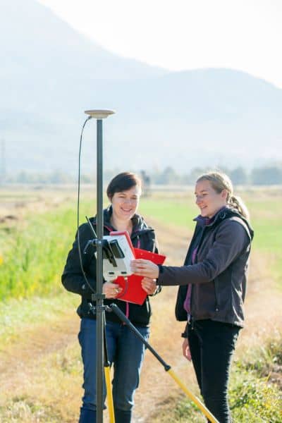
A boundary line survey marks your property corners and checks legal descriptions from deeds or maps. A licensed land surveyor places markers on the ground, draws a map, and looks for recorded easements.
In Los Angeles hillside areas, surveyors also check slope stability, shared driveways, and access points. Many use drones to survey steep land quickly and safely. The finished survey is an important document for the Los Angeles Department of Building and Safety (LADBS) and lenders during mortgage closings.
Los Angeles uses local and state tools to decide if your property is in a hazard zone. The city’s ZIMAS system shows zoning and history for each parcel. CAL FIRE maps show areas marked as Very High Fire Hazard Severity Zones. If your property is on these maps, you will likely need a boundary line survey before building or splitting your lot.
The city doesn’t allow mistakes. Setbacks, access widths, and safe spaces must be clearly shown on surveys. That’s why lenders, insurers, and FEMA rely on updated surveys to check compliance.
For homeowners, a boundary line survey gives peace of mind. After a wildfire, property lines can become unclear. Fences burn, markers disappear, and neighbors may argue about rebuilding. A survey provides certified proof to settle these disputes quickly.
For developers, a survey is more than peace of mind—it helps avoid costly delays. Imagine you design a duplex under SB 9 on a canyon lot in Studio City. During review, the city says your driveway crosses a neighbor’s easement. Without a current survey, you may have to change your whole project. A boundary line survey from the start can prevent this.
Not all surveyors are the same. A licensed land surveyor knows local codes, fire access rules, and FEMA guidelines. They also understand LADBS requirements and can file a Record of Survey if needed.
One key step is a legal property boundary check. This makes sure your property lines match official records and follow local rules. It helps prevent disputes or delays.
Technology has changed how surveys are done. Many surveyors now use drones and land mapping tools to safely survey steep or unstable land. This helps them work more accurately and safely.
When choosing a surveyor, ask if they have experience with boundary surveys in fire hazard hillside areas. Do they know how to mark defensible space on maps? These details matter when city agencies review your plans.
When should you get a survey? It depends on your plans. If you’re buying property in a high-risk zone, get a survey before closing. If you want to split a lot, order one before submitting your SB 9 application. If you’re building new structures, your surveyor can also do construction staking to make sure your buildings are placed where the city approved.
After a wildfire, many homeowners order surveys to find lost corners. Clear boundaries help with insurance claims and rebuilding permits.
Owning property comes with unique challenges. Fires change landscapes, cause disputes, and bring strict building rules. A boundary line survey is one of the best tools to stay ahead. It shows exact property limits, keeps projects legal, and reassures lenders, neighbors, and officials.
If you own or plan to build in fire-prone areas, don’t see a survey as just paperwork. See it as protection—for your property, your project, and your peace of mind.


